Namma Metro
Bangalore’s Namma Metro is a modern rapid transit network that redefines urban travel in India’s IT capital. Operational since 2011, it is the first underground metro in South India and the second-largest metro system in India, spanning 76.9 km. Operated by BMRCL (Bangalore Metro Rail Corporation Limited), the system is a blend of elevated, underground, and at-grade corridors, offering fast, reliable, and eco-friendly connectivity across the city. With two fully functional lines and four new corridors under development, the metro is revolutionizing Bangalore’s public transport.
Quick Metro Facts
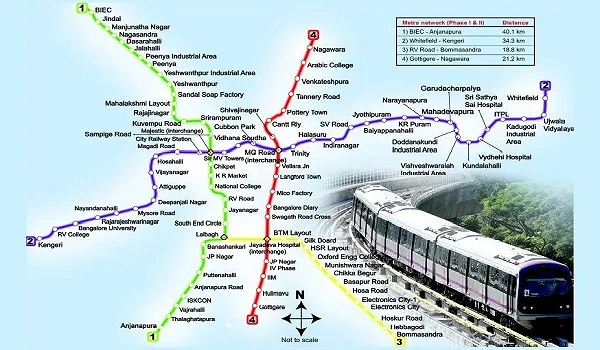
Bangalore Metro currently operates over a network length of 76.9 km, comprising 68 stations—of which 59 are elevated, 8 are underground, and 1 is at-grade. The ticket fare ranges from ₹10 to ₹45, while monthly pass options are available between ₹1000 and ₹3000, offering flexibility for regular commuters. The metro operates from 5:00 AM to 11:00 PM on weekdays, 6:00 AM to 10:30 PM on Saturdays and public holidays, and 7:00 AM to 11:00 PM on Sundays. Trains run at a high frequency, arriving approximately every 5 minutes, ensuring swift and consistent service throughout the day.
🟣 Purple Line (East–West Corridor)
The first operational metro line features 37 stations and 4 interchanges, linking Whitefield in the east to Challaghatta in the west with seamless citywide connectivity.
Stations:
The metro line connecting Whitefield in the east to Challaghatta in the west passes through several key stations that enhance citywide mobility and ease of travel. Some of the prominent stops along this route include Channasandra, Kadugodi, Pattandur Agrahara, Sri Sathya Sai Hospital, Nallurhalli, Kundalahalli, Sitharama Palya, Hoodi Junction, and Garudacharapalya. Further down the line are Mahadevapura, Swami Vivekananda Road, Indiranagar, Halasuru, Trinity, Krishnarajapuram, Benniganahalli, and Baiyappanahalli. Central city access is provided via Mahatma Gandhi Road, Cubbon Park, Dr BR Ambedkar Station, and Balagangadharanatha Swamiji Station. Westbound connectivity includes stations like Vijayanagara, Attiguppe, Deepanjali Nagara, Mysuru Road, Nayandahalli, Sir M. Visveshwaraya Station, and Nadaprabhu Kempegowda Station. Commuters also benefit from access to Krantivira Sangolli Rayanna Railway Station, Madagi Road, Rajarajeshwari Nagar, Jnanabharathi, Pattanagere, and Kengeri Bus Terminal, before reaching the final stop at Challaghatta. This comprehensive network significantly improves accessibility and reduces commute times across Bengaluru.
🟢 Green Line (North–South Corridor)
Spanning 31 kilometers with 32 stations, this metro line connects Nagasandra in the north to Silk Institute in the south, enhancing citywide transit and accessibility.
Stations:
- Madavara
- Chikkabidarakallu
- Manjunathanagara
- Peenya Industry
- Peenya
- Goraguntepalya
- Yeshwanthpura
- Sandal Soap Factory
- Nagasandra
- Dasarahalli
- Jalahalli
- Mahalakshmi
- Rajajinagara
- Mahakavi Kuvempu Road
- Srirampura
- Sampige Road
- Nadaprabhu Kempegowda Station
- Chikpete
- Yelachenahalli
- Konanakunte Cross
- Doddakallasandra
- Krishna Rajendra Market
- National College
- Lalbagh Botanical Garden
- South End Circle
- Jayanagar
- Rashtreeya Vidyalaya Road
- Banashankari
- Jaya Prakash Nagar
- Vajarahalli
- Thalaghattapura
- Silk Institute
🟡 Yellow Line (Upcoming – Launching August 2025)
This 18 km line will connect RV Road to Bommasandra, with 16 stations passing through key employment zones like Electronic City and Jayadeva Hospital.
Stations:
- RV Road
- Central Silk Board
- Bommanahalli
- Hongasandra
- Kudlu Gate
- Singasandra
- Hosa Road
- Ragigudda
- Jayadeva Hospital
- BTM Layout
- Beratena Agrahara
- Electronic City
- Konnapana Agrahara
- Bommasandra
- Huskur Road
- Hebbagodi
🔵 Blue Line (Under Construction – 58.1 km)
The upcoming Blue Line will cover 30 stations, connecting KR Puram to Kempegowda International Airport Terminal, enhancing airport access and streamlining commute across North Bangalore. It will significantly enhance airport connectivity and cover major IT zones. Godrej Aravya Estate are strategically located close to this line, making it a sought-after real estate destination.
Stations:
- KR Puram
- Mahadevpura
- Kodibisanahalli
- Kadubeesanahalli
- Bellandur
- Ibbalur
- Agara Lake
- HSR Layout
- DRDO Sports Complex
- Doddanakundi
- ISRO
- Marathahalli
- Silk Board
- DRDO Sports Complex
- Doddanakundi
- Kasturinagara
- Hebbal (interchange with Orange Line)
- Doddajala
- Horamavu
- Veerannapalya
- HRBR Layout
- Kodigehalli
- Kempegowda International Airport Terminal
- Kalyan Nagar
- Jakkur Cross
- HBR Layout
- Yelahanka
- Nagawara (Interchange with Pink Line)
- Bagalur Cross
- Kempapura
🟠 Orange Line (Phase 3 – Outer Ring Road Connectivity)
This line will connect JP Nagar to Hebbal via the Outer Ring Road, enhancing east-west city access.
Stations:
The proposed metro line connecting various parts of West and North Bangalore features key stations that will greatly enhance intra-city connectivity. Starting from Jayaprakash Nagara, the route moves through Mysuru Road, Nagarabhavi Circle, Vinayaka Layout, and the Dr Ambedkar Institute of Technology, offering access to major educational institutions and residential zones. It continues through Nagarbhavi BDA Complex, Sumanahalli Cross, Chowdeshwari Nagara, and Kadirenahalli Cross, before reaching vital transit points such as Kamakya Bus Depot and Hosakerahalli Further along the line, commuters benefit from stops at PES Institute of Technology, Freedom Fighters Cross, Kanteerava Studio, Peenya, and Bahubhali Nagara—key locations for students, workers, and daily commuters. The route then advances to prominent nodes like BEL Circle, Patelappa Layout, Hebbala, and concludes at Kempapura, significantly improving traffic flow, public transit access, and connectivity across western and northern Bangalore
🌸 Pink Line (Connecting North & South CBDs)
The Pink Line will connect Nagawara to Gottigere, supporting easy access to MG Road, IIM Bangalore, and Shivaji Nagar.
Stations:
- Kalena Agrahara
- Hulimavu
- Swagath Road Cross
- Dairy Circle
- IIM-Bangalore
- JP Nagar 4th Phase
- Jayadeva Hospital
- Lakkasandra
- Langford Town
- Rashtriya Military School
- MG Road
- Shivaji Nagar
- Cantonment
- Pottery Town
- Tannery Road
- Nagawara
- Venkateshpura
- Kadugundanahalli
Why Bangalore Metro Is Essential
Whether you’re a commuter, investor, student, or business traveler, the metro brings unmatched advantages:
- Reduces Road traffic significantly
- Increases property value in metro-connected zones
- Eco-friendly with reduced emissions
- Smooth interchange options across lines
- Digital ticketing with smartcards and apps
- Accessibility to tech parks, markets, colleges, hospitals, and the airport
Conclusion
The Bangalore Namma Metro is not just an infrastructure project—it’s the city’s pulse of mobility. As it expands to touch every major corner of the city, including outer areas like Electronic City, Hebbal, Yelahanka, and the Airport, it is becoming the backbone of Bangalore’s urban transformation. With all six lines offering seamless connections and real estate hotspots like Godrej Aravya Estate gaining proximity to metro stations, Namma Metro is set to define how Bengaluru moves—and thrives.